
In this guest post, SENSE (Satellite Data in Environmental Science) PhD student Calum Hoad discusses how his work with drones and space data can play an important part in the preservation of the sub-Arctic alpine tundra.
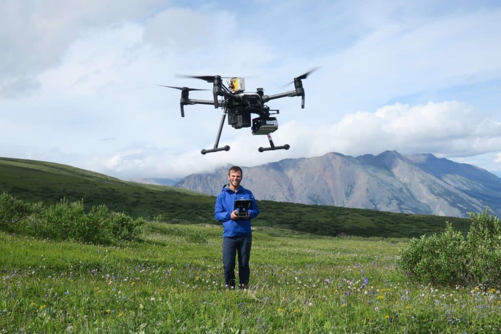
Rather than relaxing in the Scottish sunshine, I spent much of summer 2022 carrying twenty kilograms of drone equipment (as heavy as a five-year-old child) a vertical kilometre up and down a hill in the Canadian Yukon.
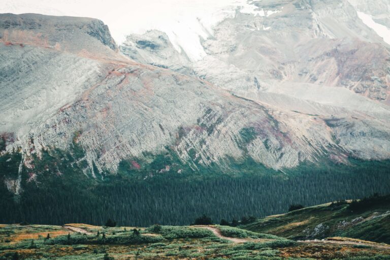
Near the top of this hill is a large area of gently sloping sub-Arctic alpine tundra. There are no trees and for most of the year, the ground is covered in snow, with only the top of small bushes like willow visible. Over the summer, while I repeatedly fly the drone, the snow melts and a wide variety of grasses and colourful flowers appear.
Willow ptarmigans scuttle around the ground with their chicks, while grizzly bears dig holes in search of burrowing mammals and plant bulbs. Beneath the surface remains a layer of permanently frozen soil (permafrost), storing enormous quantities of carbon. It’s a beautiful and important environment which can be found all the way around the top of our planet.
However, the tundra is warming up to four times as fast as the rest of the planet, affecting the plants, animals and people who live there. If permafrost soils thaw or the surface of the tundra changes slightly in colour, it may further accelerate climate change. Therefore, it’s critical that we understand how the tundra is changing.
Since we can’t visit every piece of the tundra and take measurements, scientists compare images taken by satellites over the last ~40 years to understand how the tundra is changing. By examining the unique light-reflecting properties of plants in images (they reflect lots of near-infrared light, and absorb lots of red light), many studies have found the Arctic is getting ‘greener’ at the same time as it is getting warmer. We assume a warmer tundra would be greener because it has more vegetation, but recent studies have shown in some places the tundra is getting ‘browner’, and in other places, it isn’t changing at all. The more we look the more complicated it gets.
Unfortunately, satellite images of the tundra are difficult to interpret. For example, the satellite Sentinel-2A is about 786 kilometres from Earth, which is like standing on the beach in Aberdeen and taking a picture of the German coastline. Even with a very sophisticated camera, every pixel (the little squares that make up pictures) in an image taken by Sentinel-2A covers about 10m x 10m on the ground. You’d struggle to find your house with a picture like that!
Scientists looking at the tundra with these images can see changes happening, but we can’t say with certainty what they are. Is a pixel ‘greener’ because there is more vegetation, or because there is less snow?
Which brings us to the reason I’m flying a drone on a hill in the Canadian Yukon. Underneath the drone I was flying, there are nine cameras, looking at exactly the same nine colours of light as Sentinel-2A. However, the drone takes images from just 120m above the ground, meaning it can clearly see the snow, vegetation, bare ground and rocks that make up the tundra landscape.
By comparing drone images with images from satellites, I hope to understand more precisely what changes satellites are observing at this specific piece of tundra in the Canadian Yukon. With some careful data processing, I hope to scale this understanding up, helping scientists understand what satellites are observing across all of the tundra.
If we can understand change across the whole of the tundra, we can predict how the tundra will continue to change in the future and how this may affect the rate of global climate change. Ultimately, we can then try to protect this important and beautiful environment.
Calum is one of the Co-Founders of SatSchool, an outreach programme for lower secondary school pupils to learn about Earth observation.
Connect with Calum on LinkedIn
Visit Calum’s blog
Learn more about Calum’s SatSchool team
Leave a Reply